61155705
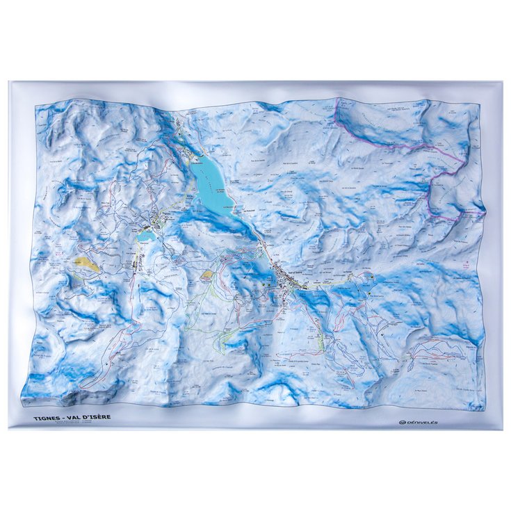
Carte Des Pistes Tignes - Val D'isere + Frame
https://www.glisshop.co.uk/maps-guides/deniveles/carte-des-pistes-tignes-val-d-isere-frame61155705
Deniveles
Men
Women
61155705
-
https://glisshop-glisshop-fr-storage.omn.proximis.com/Imagestorage/imagesSynchro/0/0/06ef812de6cdd5b924b588d511170932d1007877_E23DENIBIV376737_DENI0717271_0.jpeg
https://glisshop-glisshop-fr-storage.omn.proximis.com/Imagestorage/imagesSynchro/0/0/125e1c4423658ae7a40f2a0c5752bdf283675d28_E23DENIBIV376737_DENI0717271_901.jpeg
https://glisshop-glisshop-fr-storage.omn.proximis.com/Imagestorage/imagesSynchro/0/0/a1adfb5e171492ef72df0f7d10e5aca1b0710951_E23DENIBIV376737_DENI0717271_902.jpeg
https://glisshop-glisshop-fr-storage.omn.proximis.com/Imagestorage/imagesSynchro/0/0/d2c2672e387c39f7394be01e1414b9fb5884b46e_E23DENIBIV376737_DENI0717271_903.jpeg
https://glisshop-glisshop-fr-storage.omn.proximis.com/Imagestorage/imagesSynchro/0/0/6e0a4a069d40eb3bd8fe25e4f5934dfc51a22cf1_E23DENIBIV376737_DENI0717271_904.jpeg
https://glisshop-glisshop-fr-storage.omn.proximis.com/Imagestorage/imagesSynchro/0/0/4d1caa966af610431e08dfed19d4092d65202e76_E23DENIBIV376737_DENI0717271_905.jpeg
https://glisshop-glisshop-fr-storage.omn.proximis.com/Imagestorage/imagesSynchro/0/0/7021ef8be3a93a6033fd639e39b0d9f5363e03e9_E23DENIBIV376737_DENI0717271_906.jpeg
https://glisshop-glisshop-fr-storage.omn.proximis.com/Imagestorage/imagesSynchro/0/0/ac3223ae6d4c0078e3d5a9d6a9cd99c7f2097a0e_E23DENIBIV376737_DENI0717271_907.jpeg
https://glisshop-glisshop-fr-storage.omn.proximis.com/Imagestorage/imagesSynchro/0/0/84aef5d28cca7d600a74d419a9a5fd18e4e639c4_E23DENIBIV376737_DENI0717271_908.jpeg
InStock
80.55
GBP
80.55
GBP_VAT_royaume_uni
SEK_VAT_france
997.57
997.57
SEK
packs always have stock if there is a price
InStock
SEK_VAT_france_corse
997.57
997.57
SEK
packs always have stock if there is a price
InStock
SEK_VAT_royaume_uni
997.57
997.57
SEK
packs always have stock if there is a price
InStock
SEK_VAT_espagne
1005.89
1005.89
SEK
packs always have stock if there is a price
InStock
SEK_VAT_italie
1014.2
1014.2
SEK
packs always have stock if there is a price
InStock
SEK_VAT_allemagne
989.26
989.26
SEK
packs always have stock if there is a price
InStock
SEK_VAT_pays_bas
1005.89
1005.89
SEK
packs always have stock if there is a price
InStock
SEK_VAT_belgique
1005.89
1005.89
SEK
packs always have stock if there is a price
InStock
SEK_VAT_suisse
898.65
898.65
SEK
packs always have stock if there is a price
InStock
SEK_VAT_suede
1039.14
1039.14
SEK
packs always have stock if there is a price
InStock
SEK_VAT_danemark
997.57
997.57
SEK
packs always have stock if there is a price
InStock
SEK_VAT_monaco
997.57
997.57
SEK
packs always have stock if there is a price
InStock
SEK_VAT_luxembourg
972.63
972.63
SEK
packs always have stock if there is a price
InStock
SEK_VAT_irlande
997.57
997.57
SEK
packs always have stock if there is a price
InStock
SEK_VAT_portugal
997.57
997.57
SEK
packs always have stock if there is a price
InStock
SEK_VAT_autriche
997.57
997.57
SEK
packs always have stock if there is a price
InStock
SEK_VAT_pologne
997.57
997.57
SEK
packs always have stock if there is a price
InStock
SEK_VAT_finlande
1043.3
1043.3
SEK
packs always have stock if there is a price
InStock
SEK_VAT_slovenie
997.57
997.57
SEK
packs always have stock if there is a price
InStock
GBP_VAT_france
80.55
80.55
GBP
packs always have stock if there is a price
InStock
GBP_VAT_france_corse
80.55
80.55
GBP
packs always have stock if there is a price
InStock
GBP_VAT_espagne
81.22
81.22
GBP
packs always have stock if there is a price
InStock
GBP_VAT_italie
81.9
81.9
GBP
packs always have stock if there is a price
InStock
GBP_VAT_allemagne
79.88
79.88
GBP
packs always have stock if there is a price
InStock
GBP_VAT_pays_bas
81.22
81.22
GBP
packs always have stock if there is a price
InStock
GBP_VAT_belgique
81.22
81.22
GBP
packs always have stock if there is a price
InStock
GBP_VAT_suisse
72.56
72.56
GBP
packs always have stock if there is a price
InStock
GBP_VAT_suede
83.91
83.91
GBP
packs always have stock if there is a price
InStock
GBP_VAT_danemark
80.55
80.55
GBP
packs always have stock if there is a price
InStock
GBP_VAT_monaco
80.55
80.55
GBP
packs always have stock if there is a price
InStock
GBP_VAT_luxembourg
78.54
78.54
GBP
packs always have stock if there is a price
InStock
GBP_VAT_irlande
80.55
80.55
GBP
packs always have stock if there is a price
InStock
GBP_VAT_portugal
80.55
80.55
GBP
packs always have stock if there is a price
InStock
GBP_VAT_autriche
80.55
80.55
GBP
packs always have stock if there is a price
InStock
GBP_VAT_pologne
80.55
80.55
GBP
packs always have stock if there is a price
InStock
GBP_VAT_finlande
84.24
84.24
GBP
packs always have stock if there is a price
InStock
GBP_VAT_slovenie
80.55
80.55
GBP
packs always have stock if there is a price
InStock
CHF_VAT_france
85.92
85.92
CHF
packs always have stock if there is a price
InStock
CHF_VAT_france_corse
85.92
85.92
CHF
packs always have stock if there is a price
InStock
CHF_VAT_royaume_uni
85.92
85.92
CHF
packs always have stock if there is a price
InStock
CHF_VAT_espagne
86.64
86.64
CHF
packs always have stock if there is a price
InStock
CHF_VAT_italie
87.35
87.35
CHF
packs always have stock if there is a price
InStock
CHF_VAT_allemagne
85.2
85.2
CHF
packs always have stock if there is a price
InStock
CHF_VAT_pays_bas
86.64
86.64
CHF
packs always have stock if there is a price
InStock
CHF_VAT_belgique
86.64
86.64
CHF
packs always have stock if there is a price
InStock
CHF_VAT_suisse
77.4
77.4
CHF
packs always have stock if there is a price
InStock
CHF_VAT_suede
89.5
89.5
CHF
packs always have stock if there is a price
InStock
CHF_VAT_danemark
85.92
85.92
CHF
packs always have stock if there is a price
InStock
CHF_VAT_monaco
85.92
85.92
CHF
packs always have stock if there is a price
InStock
CHF_VAT_luxembourg
83.77
83.77
CHF
packs always have stock if there is a price
InStock
CHF_VAT_irlande
85.92
85.92
CHF
packs always have stock if there is a price
InStock
CHF_VAT_portugal
85.92
85.92
CHF
packs always have stock if there is a price
InStock
CHF_VAT_autriche
85.92
85.92
CHF
packs always have stock if there is a price
InStock
CHF_VAT_pologne
85.92
85.92
CHF
packs always have stock if there is a price
InStock
CHF_VAT_finlande
89.86
89.86
CHF
packs always have stock if there is a price
InStock
CHF_VAT_slovenie
85.92
85.92
CHF
packs always have stock if there is a price
InStock
EUR_VAT_france
89.5
89.5
EUR
packs always have stock if there is a price
InStock
EUR_VAT_france_corse
89.5
89.5
EUR
packs always have stock if there is a price
InStock
EUR_VAT_royaume_uni
89.5
89.5
EUR
packs always have stock if there is a price
InStock
EUR_VAT_espagne
90.25
90.25
EUR
packs always have stock if there is a price
InStock
EUR_VAT_italie
90.99
90.99
EUR
packs always have stock if there is a price
InStock
EUR_VAT_allemagne
88.76
88.76
EUR
packs always have stock if there is a price
InStock
EUR_VAT_pays_bas
90.25
90.25
EUR
packs always have stock if there is a price
InStock
EUR_VAT_belgique
90.25
90.25
EUR
packs always have stock if there is a price
InStock
EUR_VAT_suisse
80.63
80.63
EUR
packs always have stock if there is a price
InStock
EUR_VAT_suede
93.23
93.23
EUR
packs always have stock if there is a price
InStock
EUR_VAT_danemark
89.5
89.5
EUR
packs always have stock if there is a price
InStock
EUR_VAT_monaco
89.5
89.5
EUR
packs always have stock if there is a price
InStock
EUR_VAT_luxembourg
87.27
87.27
EUR
packs always have stock if there is a price
InStock
EUR_VAT_irlande
89.5
89.5
EUR
packs always have stock if there is a price
InStock
EUR_VAT_portugal
89.5
89.5
EUR
packs always have stock if there is a price
InStock
EUR_VAT_autriche
89.5
89.5
EUR
packs always have stock if there is a price
InStock
EUR_VAT_pologne
89.5
89.5
EUR
packs always have stock if there is a price
InStock
EUR_VAT_finlande
93.6
93.6
EUR
packs always have stock if there is a price
InStock
EUR_VAT_slovenie
89.5
89.5
EUR
packs always have stock if there is a price
InStock
/Hiking & camping/Maps - Guides
brand - 34541435
211232 - Array
211236 - GLIS_PROD_HIGHLIGHT_SEASON_56
109123 - Array
107027 - GLIS_NAME_TYPO_PRODUCT_38870
21127769 - 21127765
21127769 - 21127766
1323041 - 1386910
1323041 - 1386911
1323041 - 1386913
1323041 - 1386912


