75377052
75940359
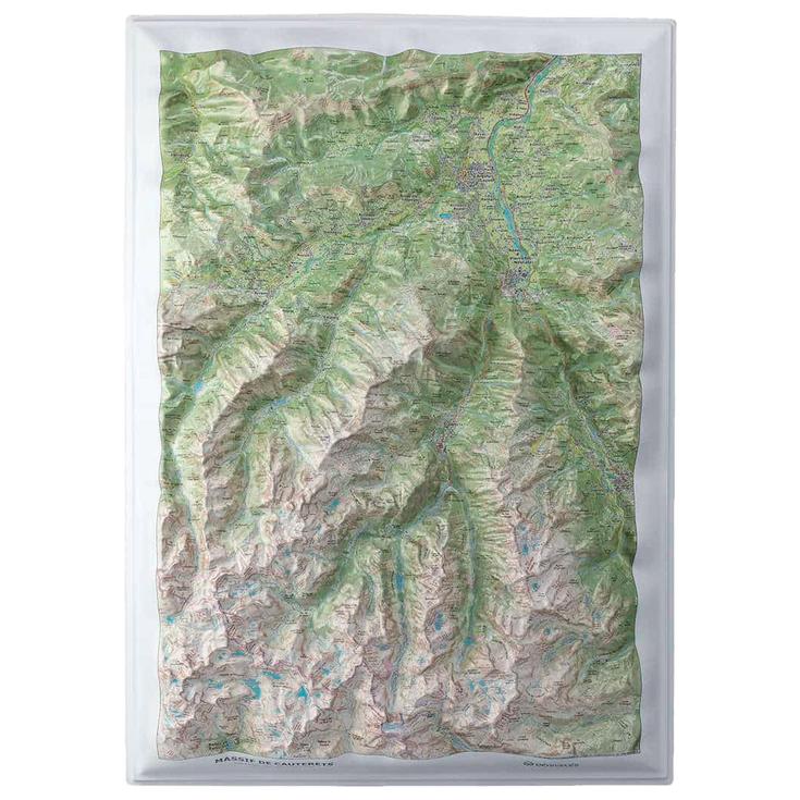
Massif de Cauterets
https://www.glisshop.co.uk/maps-guides/deniveles/massif-de-cauterets75940359
Deniveles
Men
Women
75940359
Faithful and detailed, the Dénivelés Massif de Cauterets is a 3D map that highlights the valleys, cirques and lakes of the Pyrenean massif.
https://glisshop-glisshop-fr-storage.omn.proximis.com/Imagestorage/imagesSynchro/0/0/866365198175af2c35b62b4ce5ecfefeef75e5c0_E25DENIBIV546555_DENI1271958_0.jpeg
https://glisshop-glisshop-fr-storage.omn.proximis.com/Imagestorage/imagesSynchro/0/0/aeb9b4da0ec7825defdb6635f1392c983e873ce2_E25DENIBIV546555_DENI1271958_901.jpeg
https://glisshop-glisshop-fr-storage.omn.proximis.com/Imagestorage/imagesSynchro/0/0/2ac224b3c1402bccbfaa32ac2c2ef0a5dc9bdee4_E25DENIBIV546555_DENI1271958_902.jpeg
https://glisshop-glisshop-fr-storage.omn.proximis.com/Imagestorage/imagesSynchro/0/0/1722c8811cc5c4736b620c28fd49d2044103909e_E25DENIBIV546555_DENI1271958_904.jpeg
https://glisshop-glisshop-fr-storage.omn.proximis.com/Imagestorage/imagesSynchro/0/0/c4735547be6b6716241995130b51535274457d09_E25DENIBIV546555_DENI1271958_905.jpeg
InStock
51.3
GBP
51.3
GBP_VAT_royaume_uni
GBP_VAT_france
51.3
51.3
GBP
packs always have stock if there is a price
InStock
GBP_VAT_france_corse
51.3
51.3
GBP
packs always have stock if there is a price
InStock
GBP_VAT_espagne
51.73
51.3
GBP
packs always have stock if there is a price
InStock
GBP_VAT_italie
52.16
51.3
GBP
packs always have stock if there is a price
InStock
GBP_VAT_allemagne
50.87
51.3
GBP
packs always have stock if there is a price
InStock
GBP_VAT_pays_bas
51.73
51.3
GBP
packs always have stock if there is a price
InStock
GBP_VAT_belgique
51.73
51.3
GBP
packs always have stock if there is a price
InStock
GBP_VAT_suisse
46.21
51.3
GBP
packs always have stock if there is a price
InStock
GBP_VAT_suede
53.44
51.3
GBP
packs always have stock if there is a price
InStock
GBP_VAT_danemark
51.3
51.3
GBP
packs always have stock if there is a price
InStock
GBP_VAT_monaco
51.3
51.3
GBP
packs always have stock if there is a price
InStock
GBP_VAT_luxembourg
50.02
51.3
GBP
packs always have stock if there is a price
InStock
GBP_VAT_irlande
51.3
51.3
GBP
packs always have stock if there is a price
InStock
GBP_VAT_portugal
51.3
51.3
GBP
packs always have stock if there is a price
InStock
GBP_VAT_autriche
51.3
51.3
GBP
packs always have stock if there is a price
InStock
GBP_VAT_pologne
51.3
51.3
GBP
packs always have stock if there is a price
InStock
GBP_VAT_finlande
53.65
51.3
GBP
packs always have stock if there is a price
InStock
GBP_VAT_slovenie
51.3
51.3
GBP
packs always have stock if there is a price
InStock
CHF_VAT_france
54.72
54.72
CHF
packs always have stock if there is a price
InStock
CHF_VAT_france_corse
54.72
54.72
CHF
packs always have stock if there is a price
InStock
CHF_VAT_royaume_uni
54.72
54.72
CHF
packs always have stock if there is a price
InStock
CHF_VAT_espagne
55.18
54.72
CHF
packs always have stock if there is a price
InStock
CHF_VAT_italie
55.63
54.72
CHF
packs always have stock if there is a price
InStock
CHF_VAT_allemagne
54.26
54.72
CHF
packs always have stock if there is a price
InStock
CHF_VAT_pays_bas
55.18
54.72
CHF
packs always have stock if there is a price
InStock
CHF_VAT_belgique
55.18
54.72
CHF
packs always have stock if there is a price
InStock
CHF_VAT_suisse
49.29
54.72
CHF
packs always have stock if there is a price
InStock
CHF_VAT_suede
57
54.72
CHF
packs always have stock if there is a price
InStock
CHF_VAT_danemark
54.72
54.72
CHF
packs always have stock if there is a price
InStock
CHF_VAT_monaco
54.72
54.72
CHF
packs always have stock if there is a price
InStock
CHF_VAT_luxembourg
53.35
54.72
CHF
packs always have stock if there is a price
InStock
CHF_VAT_irlande
54.72
54.72
CHF
packs always have stock if there is a price
InStock
CHF_VAT_portugal
54.72
54.72
CHF
packs always have stock if there is a price
InStock
CHF_VAT_autriche
54.72
54.72
CHF
packs always have stock if there is a price
InStock
CHF_VAT_pologne
54.72
54.72
CHF
packs always have stock if there is a price
InStock
CHF_VAT_finlande
57.23
54.72
CHF
packs always have stock if there is a price
InStock
CHF_VAT_slovenie
54.72
54.72
CHF
packs always have stock if there is a price
InStock
EUR_VAT_france
57
57
EUR
packs always have stock if there is a price
InStock
EUR_VAT_france_corse
57
57
EUR
packs always have stock if there is a price
InStock
EUR_VAT_royaume_uni
57
57
EUR
packs always have stock if there is a price
InStock
EUR_VAT_espagne
57.48
57
EUR
packs always have stock if there is a price
InStock
EUR_VAT_italie
57.95
57
EUR
packs always have stock if there is a price
InStock
EUR_VAT_allemagne
56.53
57
EUR
packs always have stock if there is a price
InStock
EUR_VAT_pays_bas
57.48
57
EUR
packs always have stock if there is a price
InStock
EUR_VAT_belgique
57.48
57
EUR
packs always have stock if there is a price
InStock
EUR_VAT_suisse
51.35
57
EUR
packs always have stock if there is a price
InStock
EUR_VAT_suede
59.38
57
EUR
packs always have stock if there is a price
InStock
EUR_VAT_danemark
57
57
EUR
packs always have stock if there is a price
InStock
EUR_VAT_monaco
57
57
EUR
packs always have stock if there is a price
InStock
EUR_VAT_luxembourg
55.58
57
EUR
packs always have stock if there is a price
InStock
EUR_VAT_irlande
57
57
EUR
packs always have stock if there is a price
InStock
EUR_VAT_portugal
57
57
EUR
packs always have stock if there is a price
InStock
EUR_VAT_autriche
57
57
EUR
packs always have stock if there is a price
InStock
EUR_VAT_pologne
57
57
EUR
packs always have stock if there is a price
InStock
EUR_VAT_finlande
59.61
57
EUR
packs always have stock if there is a price
InStock
EUR_VAT_slovenie
57
57
EUR
packs always have stock if there is a price
InStock
/Hiking & camping/Maps - Guides
/Hiking & camping
brand - 34541435
211232 - 1
107027 - GLIS_NAME_TYPO_PRODUCT_38870
109123 - Sans
21127769 - 21127765
21127769 - 21127766
1323041 - 1386915
1323041 - 27033930


