CONTACT US   020 3129 3301

Our experts are here for you

Our passionate staff is with you through every step of your purchase and helps you choose the right gear that best suits your needs.

Mon-Sat 9am-12am / 2pm-7pm

(GMT+1)

020 3129 3301  


With our Help Center

CONTACT
(= line.product.common.ancestorIds[1] || line.product.common.ancestorIds[0] || line.product.common.id =) (= line.quantity =) (= line.product.common.title =) (= line.unitAmountWithTaxes =) (= cartData.common.currencyCode =)
3DMAP Carte 3D Vercors Chartreuse Overview

3DMAP

Customer reviews

Set Vercors-Chartreuse +


Image not available
Brand 3DMAP

Set Vercors-Chartreuse +

Customer reviews

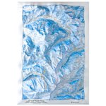
This French-made 3D map brings an incredible level of detail and quality to the Vercors Chartreuse region represented on this model.

Please make sure the following options are correct

Select Map

+

Included

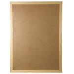
Raised-relief map 3DMAP Cadre

Specifications
Please select the specs needed.
(= visuals[0].alt =)
Pay by card with ONEY
In Or ?
Your cart payment is pending. Finalise or cancel your payment before modifying it.
Finalise your order
Pay by card with ONEY
In Or ?

Earliest delivery 2024-04-01T01:00:00+02:00

  • SECURE PAYMENT

    by card

    View conditions
  • Custom fees included

    in the shipping fees

    View conditions
  • 100 DAYS

    for changing your mind

    View conditions

Description

3DMAP maps are made in France and bring a new dimension to cartography, both literally and figuratively. Thanks to 3D processing software developed specifically for these maps, an exceptional level of finish is achieved, making these maps as beautiful as they are detailed. Here, the entire Vercors and Chartreuse massif is represented. From sporting sites (paragliding, skiing, whitewater) to tourist sites (villages, museums, caves), you can discover this beautiful region as if you were there.

Technical features:

  • Tourist sites: Plus beaux villages de France, Stations thermales, Sept merveilles du Dauphiné, Patrimoine culturel, Religieux, Musées, Grottes, Sites naturels, Cascades, Tables d'orientation, Belvédères, Observatoires astronomiques, Maisons (Parc naturel régional, PNR)
  • Sports sites, hiking: Refuges, Gites d'étape, Sentiers de Grandes Randonnées (GR), Grand Tour du Vercors pédestre, Tour de Chartreuse, Autres sentiers, Stations de ski alpin, de ski nordique, Via Ferrata, Activités en eau vive, Beaches, Golfs, Sites de pratique du parapente (www.ffvl.fr), Take-offs, Landings, Airports, Airfields, Railway stations, Departmental boundaries
  • Dimensions: 610 x 410 mm
  • Scale: 1 / 220,000
  • Made in France
  • Frame sold separately

This description is an automatic translation. Please contact us if you have any further questions.

Emilien

Accessory expert

"Some look for functionality, others for style or performance. Whatever it is, we'll find it together and make sure we add the safety dimension to it! Call me on 020 3129 3301."

Technical data Raised-relief map Vercors-Chartreuse

  • Gender

    Men
    Women
  • EAN code

    9791097206055
  • Reference nr

    3DMA0206837
  • SKU

    VERCHA16
  • Destination

    France