61156875
Tignes-Val D'isère + Frame
https://www.glisshop.co.uk/maps-guides/3dmap/tignes-val-d-isere-frame61156875
3DMAP
Men
Women
61156875
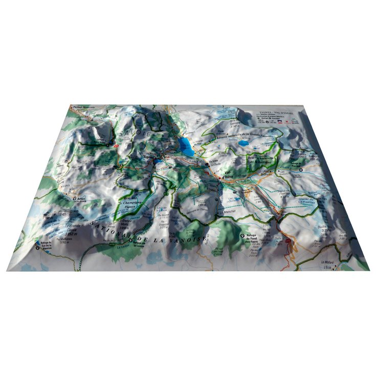
On this 3D map of the Tignes Val d'Isère region, you can observe all the topography of the area and spot various points of interest such as GR trails, paragliding sites, etc.
.
https://glisshop-glisshop-fr-storage.omn.proximis.com/Imagestorage/imagesSynchro/0/0/595e4efdda81facc4860f22d2f9303797541eefe_E233DMABIV348450_3DMA0206848_0.jpeg
https://glisshop-glisshop-fr-storage.omn.proximis.com/Imagestorage/imagesSynchro/0/0/6148b4bc0b4b9c2fcf44d512fac1515ebc087513_E233DMABIV348450_3DMA0206848_2.jpeg
https://glisshop-glisshop-fr-storage.omn.proximis.com/Imagestorage/imagesSynchro/0/0/1712b1d0a1f7b071303aa44cb0773c5dc25bd674_E233DMABIV348450_3DMA0206848_901.jpeg
https://glisshop-glisshop-fr-storage.omn.proximis.com/Imagestorage/imagesSynchro/0/0/7f057086ea5e86aa0070edab7972bdaf350814c5_E233DMABIV348450_3DMA0206848_902.jpeg
https://glisshop-glisshop-fr-storage.omn.proximis.com/Imagestorage/imagesSynchro/0/0/89188b623cc9640df72a509a7419bcbf0bb5f444_E233DMABIV348450_3DMA0206848_903.jpeg
InStock
31.32
GBP
31.32
GBP_VAT_royaume_uni
GBP_VAT_france
31.32
31.32
GBP
packs always have stock if there is a price
InStock
GBP_VAT_france_corse
31.32
31.32
GBP
packs always have stock if there is a price
InStock
GBP_VAT_espagne
31.58
31.58
GBP
packs always have stock if there is a price
InStock
GBP_VAT_italie
31.84
31.84
GBP
packs always have stock if there is a price
InStock
GBP_VAT_allemagne
31.06
31.06
GBP
packs always have stock if there is a price
InStock
GBP_VAT_pays_bas
31.58
31.58
GBP
packs always have stock if there is a price
InStock
GBP_VAT_belgique
31.58
31.58
GBP
packs always have stock if there is a price
InStock
GBP_VAT_suisse
28.21
28.21
GBP
packs always have stock if there is a price
InStock
GBP_VAT_suede
32.63
32.63
GBP
packs always have stock if there is a price
InStock
GBP_VAT_danemark
31.32
31.32
GBP
packs always have stock if there is a price
InStock
GBP_VAT_monaco
31.32
31.32
GBP
packs always have stock if there is a price
InStock
GBP_VAT_luxembourg
30.53
30.53
GBP
packs always have stock if there is a price
InStock
GBP_VAT_irlande
31.32
31.32
GBP
packs always have stock if there is a price
InStock
GBP_VAT_portugal
31.32
31.32
GBP
packs always have stock if there is a price
InStock
GBP_VAT_autriche
31.32
31.32
GBP
packs always have stock if there is a price
InStock
GBP_VAT_pologne
31.32
31.32
GBP
packs always have stock if there is a price
InStock
GBP_VAT_finlande
32.75
32.75
GBP
packs always have stock if there is a price
InStock
GBP_VAT_slovenie
31.32
31.32
GBP
packs always have stock if there is a price
InStock
CHF_VAT_france
33.4
33.4
CHF
packs always have stock if there is a price
InStock
CHF_VAT_france_corse
33.4
33.4
CHF
packs always have stock if there is a price
InStock
CHF_VAT_royaume_uni
33.4
33.4
CHF
packs always have stock if there is a price
InStock
CHF_VAT_espagne
33.68
33.68
CHF
packs always have stock if there is a price
InStock
CHF_VAT_italie
33.96
33.96
CHF
packs always have stock if there is a price
InStock
CHF_VAT_allemagne
33.12
33.12
CHF
packs always have stock if there is a price
InStock
CHF_VAT_pays_bas
33.68
33.68
CHF
packs always have stock if there is a price
InStock
CHF_VAT_belgique
33.68
33.68
CHF
packs always have stock if there is a price
InStock
CHF_VAT_suisse
30.1
30.1
CHF
packs always have stock if there is a price
InStock
CHF_VAT_suede
34.8
34.8
CHF
packs always have stock if there is a price
InStock
CHF_VAT_danemark
33.4
33.4
CHF
packs always have stock if there is a price
InStock
CHF_VAT_monaco
33.4
33.4
CHF
packs always have stock if there is a price
InStock
CHF_VAT_luxembourg
32.58
32.58
CHF
packs always have stock if there is a price
InStock
CHF_VAT_irlande
33.4
33.4
CHF
packs always have stock if there is a price
InStock
CHF_VAT_portugal
33.4
33.4
CHF
packs always have stock if there is a price
InStock
CHF_VAT_autriche
33.4
33.4
CHF
packs always have stock if there is a price
InStock
CHF_VAT_pologne
33.4
33.4
CHF
packs always have stock if there is a price
InStock
CHF_VAT_finlande
34.94
34.94
CHF
packs always have stock if there is a price
InStock
CHF_VAT_slovenie
33.4
33.4
CHF
packs always have stock if there is a price
InStock
EUR_VAT_france
34.8
34.8
EUR
packs always have stock if there is a price
InStock
EUR_VAT_france_corse
34.8
34.8
EUR
packs always have stock if there is a price
InStock
EUR_VAT_royaume_uni
34.8
34.8
EUR
packs always have stock if there is a price
InStock
EUR_VAT_espagne
35.09
35.09
EUR
packs always have stock if there is a price
InStock
EUR_VAT_italie
35.38
35.38
EUR
packs always have stock if there is a price
InStock
EUR_VAT_allemagne
34.51
34.51
EUR
packs always have stock if there is a price
InStock
EUR_VAT_pays_bas
35.09
35.09
EUR
packs always have stock if there is a price
InStock
EUR_VAT_belgique
35.09
35.09
EUR
packs always have stock if there is a price
InStock
EUR_VAT_suisse
31.35
31.35
EUR
packs always have stock if there is a price
InStock
EUR_VAT_suede
36.25
36.25
EUR
packs always have stock if there is a price
InStock
EUR_VAT_danemark
34.8
34.8
EUR
packs always have stock if there is a price
InStock
EUR_VAT_monaco
34.8
34.8
EUR
packs always have stock if there is a price
InStock
EUR_VAT_luxembourg
33.93
33.93
EUR
packs always have stock if there is a price
InStock
EUR_VAT_irlande
34.8
34.8
EUR
packs always have stock if there is a price
InStock
EUR_VAT_portugal
34.8
34.8
EUR
packs always have stock if there is a price
InStock
EUR_VAT_autriche
34.8
34.8
EUR
packs always have stock if there is a price
InStock
EUR_VAT_pologne
34.8
34.8
EUR
packs always have stock if there is a price
InStock
EUR_VAT_finlande
36.39
36.39
EUR
packs always have stock if there is a price
InStock
EUR_VAT_slovenie
34.8
34.8
EUR
packs always have stock if there is a price
InStock
/Hiking & camping/Maps - Guides
brand - 39543876
211232 - Array
211236 - GLIS_PROD_HIGHLIGHT_SEASON_55
109123 - Array
107027 - GLIS_NAME_TYPO_PRODUCT_38870
21127769 - 21127765
21127769 - 21127766


