68050449
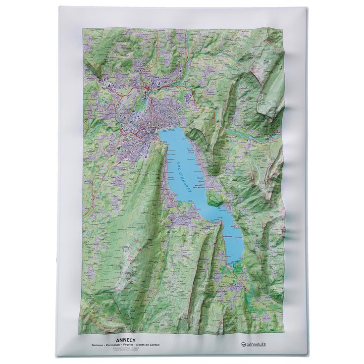
Lac d'Annecy + Frame
https://www.glisshop.co.uk/maps-guides/deniveles/lac-d-annecy-frame68050449
Deniveles
Men
Women
68050449
Provided by the publishing company Dénivelés, this relief map immerses you in the massifs overlooking Lake Annecy, allowing you to plan your next excursions with great precision.
https://glisshop-glisshop-fr-storage.omn.proximis.com/Imagestorage/imagesSynchro/0/0/5cc01ef99a6225de78ac1a992b5c94fb1b1a3ad1_E22DENIBIV268876_DENI0676531_0.jpeg
https://glisshop-glisshop-fr-storage.omn.proximis.com/Imagestorage/imagesSynchro/0/0/e3bce12db8c677bc0cbf92954ab155b950f4606b_E22DENIBIV268876_DENI0676531_10.jpeg
https://glisshop-glisshop-fr-storage.omn.proximis.com/Imagestorage/imagesSynchro/0/0/f5328a0cff02d892e48e8c5aeb3943ec77c2bc6e_E22DENIBIV268876_DENI0676531_11.jpeg
https://glisshop-glisshop-fr-storage.omn.proximis.com/Imagestorage/imagesSynchro/0/0/795b67830a2e3f6932f64b4d2c3aa0b9bf1f1588_E22DENIBIV268876_DENI0676531_12.jpeg
InStock
78.67
GBP
78.67
GBP_VAT_royaume_uni
SEK_VAT_france
997.57
997.57
SEK
packs always have stock if there is a price
InStock
SEK_VAT_france_corse
997.57
997.57
SEK
packs always have stock if there is a price
InStock
SEK_VAT_royaume_uni
997.57
997.57
SEK
packs always have stock if there is a price
InStock
SEK_VAT_espagne
1005.89
1005.89
SEK
packs always have stock if there is a price
InStock
SEK_VAT_italie
1014.2
1014.2
SEK
packs always have stock if there is a price
InStock
SEK_VAT_allemagne
989.26
989.26
SEK
packs always have stock if there is a price
InStock
SEK_VAT_pays_bas
1005.89
1005.89
SEK
packs always have stock if there is a price
InStock
SEK_VAT_belgique
1005.89
1005.89
SEK
packs always have stock if there is a price
InStock
SEK_VAT_suisse
898.65
898.65
SEK
packs always have stock if there is a price
InStock
SEK_VAT_suede
1039.14
1039.14
SEK
packs always have stock if there is a price
InStock
SEK_VAT_danemark
997.57
997.57
SEK
packs always have stock if there is a price
InStock
SEK_VAT_monaco
997.57
997.57
SEK
packs always have stock if there is a price
InStock
SEK_VAT_luxembourg
972.63
972.63
SEK
packs always have stock if there is a price
InStock
SEK_VAT_irlande
997.57
997.57
SEK
packs always have stock if there is a price
InStock
SEK_VAT_portugal
997.57
997.57
SEK
packs always have stock if there is a price
InStock
SEK_VAT_autriche
997.57
997.57
SEK
packs always have stock if there is a price
InStock
SEK_VAT_pologne
997.57
997.57
SEK
packs always have stock if there is a price
InStock
SEK_VAT_finlande
1043.3
1043.3
SEK
packs always have stock if there is a price
InStock
SEK_VAT_slovenie
997.57
997.57
SEK
packs always have stock if there is a price
InStock
GBP_VAT_france
78.67
78.67
GBP
packs always have stock if there is a price
InStock
GBP_VAT_france_corse
78.67
78.67
GBP
packs always have stock if there is a price
InStock
GBP_VAT_espagne
79.33
79.33
GBP
packs always have stock if there is a price
InStock
GBP_VAT_italie
79.99
79.99
GBP
packs always have stock if there is a price
InStock
GBP_VAT_allemagne
78.01
78.01
GBP
packs always have stock if there is a price
InStock
GBP_VAT_pays_bas
79.33
79.33
GBP
packs always have stock if there is a price
InStock
GBP_VAT_belgique
79.33
79.33
GBP
packs always have stock if there is a price
InStock
GBP_VAT_suisse
70.87
70.87
GBP
packs always have stock if there is a price
InStock
GBP_VAT_suede
81.95
81.95
GBP
packs always have stock if there is a price
InStock
GBP_VAT_danemark
78.67
78.67
GBP
packs always have stock if there is a price
InStock
GBP_VAT_monaco
78.67
78.67
GBP
packs always have stock if there is a price
InStock
GBP_VAT_luxembourg
76.7
76.7
GBP
packs always have stock if there is a price
InStock
GBP_VAT_irlande
78.67
78.67
GBP
packs always have stock if there is a price
InStock
GBP_VAT_portugal
78.67
78.67
GBP
packs always have stock if there is a price
InStock
GBP_VAT_autriche
78.67
78.67
GBP
packs always have stock if there is a price
InStock
GBP_VAT_pologne
78.67
78.67
GBP
packs always have stock if there is a price
InStock
GBP_VAT_finlande
82.28
82.28
GBP
packs always have stock if there is a price
InStock
GBP_VAT_slovenie
78.67
78.67
GBP
packs always have stock if there is a price
InStock
CHF_VAT_france
85.82
85.82
CHF
packs always have stock if there is a price
InStock
CHF_VAT_france_corse
85.82
85.82
CHF
packs always have stock if there is a price
InStock
CHF_VAT_royaume_uni
85.82
85.82
CHF
packs always have stock if there is a price
InStock
CHF_VAT_espagne
86.54
86.54
CHF
packs always have stock if there is a price
InStock
CHF_VAT_italie
87.25
87.25
CHF
packs always have stock if there is a price
InStock
CHF_VAT_allemagne
85.11
85.11
CHF
packs always have stock if there is a price
InStock
CHF_VAT_pays_bas
86.54
86.54
CHF
packs always have stock if there is a price
InStock
CHF_VAT_belgique
86.54
86.54
CHF
packs always have stock if there is a price
InStock
CHF_VAT_suisse
77.32
77.32
CHF
packs always have stock if there is a price
InStock
CHF_VAT_suede
89.4
89.4
CHF
packs always have stock if there is a price
InStock
CHF_VAT_danemark
85.82
85.82
CHF
packs always have stock if there is a price
InStock
CHF_VAT_monaco
85.82
85.82
CHF
packs always have stock if there is a price
InStock
CHF_VAT_luxembourg
83.68
83.68
CHF
packs always have stock if there is a price
InStock
CHF_VAT_irlande
85.82
85.82
CHF
packs always have stock if there is a price
InStock
CHF_VAT_portugal
85.82
85.82
CHF
packs always have stock if there is a price
InStock
CHF_VAT_autriche
85.82
85.82
CHF
packs always have stock if there is a price
InStock
CHF_VAT_pologne
85.82
85.82
CHF
packs always have stock if there is a price
InStock
CHF_VAT_finlande
89.76
89.76
CHF
packs always have stock if there is a price
InStock
CHF_VAT_slovenie
85.82
85.82
CHF
packs always have stock if there is a price
InStock
EUR_VAT_france
89.4
89.4
EUR
packs always have stock if there is a price
InStock
EUR_VAT_france_corse
89.4
89.4
EUR
packs always have stock if there is a price
InStock
EUR_VAT_royaume_uni
89.4
89.4
EUR
packs always have stock if there is a price
InStock
EUR_VAT_espagne
90.14
90.14
EUR
packs always have stock if there is a price
InStock
EUR_VAT_italie
90.89
90.89
EUR
packs always have stock if there is a price
InStock
EUR_VAT_allemagne
88.66
88.66
EUR
packs always have stock if there is a price
InStock
EUR_VAT_pays_bas
90.14
90.14
EUR
packs always have stock if there is a price
InStock
EUR_VAT_belgique
90.14
90.14
EUR
packs always have stock if there is a price
InStock
EUR_VAT_suisse
80.54
80.54
EUR
packs always have stock if there is a price
InStock
EUR_VAT_suede
93.12
93.12
EUR
packs always have stock if there is a price
InStock
EUR_VAT_danemark
89.4
89.4
EUR
packs always have stock if there is a price
InStock
EUR_VAT_monaco
89.4
89.4
EUR
packs always have stock if there is a price
InStock
EUR_VAT_luxembourg
87.17
87.17
EUR
packs always have stock if there is a price
InStock
EUR_VAT_irlande
89.4
89.4
EUR
packs always have stock if there is a price
InStock
EUR_VAT_portugal
89.4
89.4
EUR
packs always have stock if there is a price
InStock
EUR_VAT_autriche
89.4
89.4
EUR
packs always have stock if there is a price
InStock
EUR_VAT_pologne
89.4
89.4
EUR
packs always have stock if there is a price
InStock
EUR_VAT_finlande
93.5
93.5
EUR
packs always have stock if there is a price
InStock
EUR_VAT_slovenie
89.4
89.4
EUR
packs always have stock if there is a price
InStock
/Hiking & camping/Maps - Guides
brand - 34541435
211232 - Array
211236 - GLIS_PROD_HIGHLIGHT_SEASON_56
109123 - Array
107027 - GLIS_NAME_TYPO_PRODUCT_38870
21127769 - 21127765
21127769 - 21127766
1323041 - 1386915
1323041 - 27033930


