68050521
Le Devoluy + Frame
https://www.glisshop.co.uk/maps-guides/deniveles/le-devoluy-frame68050521
Deniveles
Men
Women
68050521
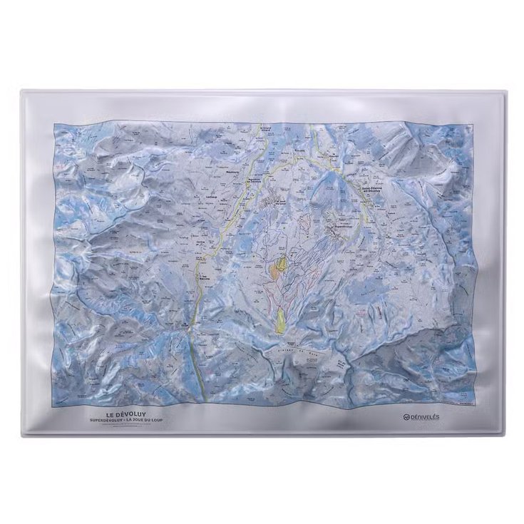
Deniveles' Le Devoluy 3D map is a detailed representation of the Dévoluy massif, highlighting its relief and trails for precise exploration of this mountainous region.
https://glisshop-glisshop-fr-storage.omn.proximis.com/Imagestorage/imagesSynchro/0/0/f99af490e17a7d9d14d01788485b4d03f86ae13b_E25DENIBIV486522_DENI1091770_0.jpeg
https://glisshop-glisshop-fr-storage.omn.proximis.com/Imagestorage/imagesSynchro/0/0/f54fa575af0e29ac3f2dc655156fc84e0283c878_E25DENIBIV486522_DENI1091770_901.jpeg
https://glisshop-glisshop-fr-storage.omn.proximis.com/Imagestorage/imagesSynchro/0/0/8c623be22824247bed872ffbce24f156218e2316_E25DENIBIV486522_DENI1091770_902.jpeg
https://glisshop-glisshop-fr-storage.omn.proximis.com/Imagestorage/imagesSynchro/0/0/8c8b82c11fbe84d04d84f687c8b18d07eed9c35a_E25DENIBIV486522_DENI1091770_903.jpeg
https://glisshop-glisshop-fr-storage.omn.proximis.com/Imagestorage/imagesSynchro/0/0/364b2e767d48187a731532b7556c885122c42c0e_E25DENIBIV486522_DENI1091770_904.jpeg
https://glisshop-glisshop-fr-storage.omn.proximis.com/Imagestorage/imagesSynchro/0/0/ff8ce0c8c0005ff434257e10445642efeb9659b5_E25DENIBIV486522_DENI1091770_905.jpeg
https://glisshop-glisshop-fr-storage.omn.proximis.com/Imagestorage/imagesSynchro/0/0/a5688a22626c2c2041fbd189df64cef4a9e69664_E25DENIBIV486522_DENI1091770_910.jpeg
InStock
78.66
GBP
78.66
GBP_VAT_royaume_uni
GBP_VAT_france
78.66
78.66
GBP
packs always have stock if there is a price
InStock
GBP_VAT_france_corse
78.66
78.66
GBP
packs always have stock if there is a price
InStock
GBP_VAT_espagne
79.31
79.31
GBP
packs always have stock if there is a price
InStock
GBP_VAT_italie
79.97
79.97
GBP
packs always have stock if there is a price
InStock
GBP_VAT_allemagne
78.01
78.01
GBP
packs always have stock if there is a price
InStock
GBP_VAT_pays_bas
79.31
79.31
GBP
packs always have stock if there is a price
InStock
GBP_VAT_belgique
79.31
79.31
GBP
packs always have stock if there is a price
InStock
GBP_VAT_suisse
70.86
70.86
GBP
packs always have stock if there is a price
InStock
GBP_VAT_suede
81.94
81.94
GBP
packs always have stock if there is a price
InStock
GBP_VAT_danemark
78.66
78.66
GBP
packs always have stock if there is a price
InStock
GBP_VAT_monaco
78.66
78.66
GBP
packs always have stock if there is a price
InStock
GBP_VAT_luxembourg
76.69
76.69
GBP
packs always have stock if there is a price
InStock
GBP_VAT_irlande
78.66
78.66
GBP
packs always have stock if there is a price
InStock
GBP_VAT_portugal
78.66
78.66
GBP
packs always have stock if there is a price
InStock
GBP_VAT_autriche
78.66
78.66
GBP
packs always have stock if there is a price
InStock
GBP_VAT_pologne
78.66
78.66
GBP
packs always have stock if there is a price
InStock
GBP_VAT_finlande
82.26
82.26
GBP
packs always have stock if there is a price
InStock
GBP_VAT_slovenie
78.66
78.66
GBP
packs always have stock if there is a price
InStock
CHF_VAT_france
83.9
83.9
CHF
packs always have stock if there is a price
InStock
CHF_VAT_france_corse
83.9
83.9
CHF
packs always have stock if there is a price
InStock
CHF_VAT_royaume_uni
83.9
83.9
CHF
packs always have stock if there is a price
InStock
CHF_VAT_espagne
84.6
84.6
CHF
packs always have stock if there is a price
InStock
CHF_VAT_italie
85.3
85.3
CHF
packs always have stock if there is a price
InStock
CHF_VAT_allemagne
83.2
83.2
CHF
packs always have stock if there is a price
InStock
CHF_VAT_pays_bas
84.6
84.6
CHF
packs always have stock if there is a price
InStock
CHF_VAT_belgique
84.6
84.6
CHF
packs always have stock if there is a price
InStock
CHF_VAT_suisse
75.59
75.59
CHF
packs always have stock if there is a price
InStock
CHF_VAT_suede
87.4
87.4
CHF
packs always have stock if there is a price
InStock
CHF_VAT_danemark
83.9
83.9
CHF
packs always have stock if there is a price
InStock
CHF_VAT_monaco
83.9
83.9
CHF
packs always have stock if there is a price
InStock
CHF_VAT_luxembourg
81.81
81.81
CHF
packs always have stock if there is a price
InStock
CHF_VAT_irlande
83.9
83.9
CHF
packs always have stock if there is a price
InStock
CHF_VAT_portugal
83.9
83.9
CHF
packs always have stock if there is a price
InStock
CHF_VAT_autriche
83.9
83.9
CHF
packs always have stock if there is a price
InStock
CHF_VAT_pologne
83.9
83.9
CHF
packs always have stock if there is a price
InStock
CHF_VAT_finlande
87.75
87.75
CHF
packs always have stock if there is a price
InStock
CHF_VAT_slovenie
83.9
83.9
CHF
packs always have stock if there is a price
InStock
EUR_VAT_france
87.4
87.4
EUR
packs always have stock if there is a price
InStock
EUR_VAT_france_corse
87.4
87.4
EUR
packs always have stock if there is a price
InStock
EUR_VAT_royaume_uni
87.4
87.4
EUR
packs always have stock if there is a price
InStock
EUR_VAT_espagne
88.13
88.13
EUR
packs always have stock if there is a price
InStock
EUR_VAT_italie
88.86
88.86
EUR
packs always have stock if there is a price
InStock
EUR_VAT_allemagne
86.67
86.67
EUR
packs always have stock if there is a price
InStock
EUR_VAT_pays_bas
88.13
88.13
EUR
packs always have stock if there is a price
InStock
EUR_VAT_belgique
88.13
88.13
EUR
packs always have stock if there is a price
InStock
EUR_VAT_suisse
78.74
78.74
EUR
packs always have stock if there is a price
InStock
EUR_VAT_suede
91.04
91.04
EUR
packs always have stock if there is a price
InStock
EUR_VAT_danemark
87.4
87.4
EUR
packs always have stock if there is a price
InStock
EUR_VAT_monaco
87.4
87.4
EUR
packs always have stock if there is a price
InStock
EUR_VAT_luxembourg
85.22
85.22
EUR
packs always have stock if there is a price
InStock
EUR_VAT_irlande
87.4
87.4
EUR
packs always have stock if there is a price
InStock
EUR_VAT_portugal
87.4
87.4
EUR
packs always have stock if there is a price
InStock
EUR_VAT_autriche
87.4
87.4
EUR
packs always have stock if there is a price
InStock
EUR_VAT_pologne
87.4
87.4
EUR
packs always have stock if there is a price
InStock
EUR_VAT_finlande
91.41
91.41
EUR
packs always have stock if there is a price
InStock
EUR_VAT_slovenie
87.4
87.4
EUR
packs always have stock if there is a price
InStock
/Hiking & camping/Maps - Guides
brand - 34541435
211232 - Array
211236 - GLIS_PROD_HIGHLIGHT_SEASON_40145
109123 - Array
107027 - GLIS_NAME_TYPO_PRODUCT_38870
21127769 - 21127765
21127769 - 21127766
1323041 - 1386915
1323041 - 1386911


