41431794
43481090
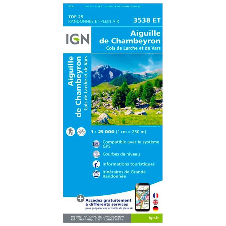
3538ET Aiguille de Chambeyron Cols de Larche et de Vars
https://www.glisshop.co.uk/maps-guides/ign/3538et-aiguille-de-chambeyron-cols-de-larche-et-de-vars43481090
IGN
Men
Women
43481090
IGN map 3538ET Aiguille de Chambeyron Cols de Larche et de Vars allows you to discover this region in great detail. Scale 1:25,000
https://glisshop-glisshop-fr-storage.omn.proximis.com/Imagestorage/imagesSynchro/0/0/7c698df59908294aecfbfd23863a86b1ce31a0db_H230IGNBIV355972_0IGN0211166_0.jpeg
https://glisshop-glisshop-fr-storage.omn.proximis.com/Imagestorage/imagesSynchro/0/0/098bbe956dbbd82ba12eea1f3c1cc95f19646297_H230IGNBIV355972_0IGN0211166_2.jpeg
OutOfStock
10.71
GBP
12.06
GBP_VAT_royaume_uni
SEK_VAT_france
157.45
157.45
SEK
packs always have stock if there is a price
Unavailable
SEK_VAT_france_corse
157.45
157.45
SEK
packs always have stock if there is a price
Unavailable
SEK_VAT_royaume_uni
157.45
157.45
SEK
packs always have stock if there is a price
Unavailable
SEK_VAT_espagne
158.76
157.45
SEK
packs always have stock if there is a price
Unavailable
SEK_VAT_italie
160.07
157.45
SEK
packs always have stock if there is a price
Unavailable
SEK_VAT_allemagne
156.14
157.45
SEK
packs always have stock if there is a price
Unavailable
SEK_VAT_pays_bas
158.76
157.45
SEK
packs always have stock if there is a price
Unavailable
SEK_VAT_belgique
158.76
157.45
SEK
packs always have stock if there is a price
Unavailable
SEK_VAT_suisse
141.84
157.45
SEK
packs always have stock if there is a price
Unavailable
SEK_VAT_suede
164.01
157.45
SEK
packs always have stock if there is a price
Unavailable
SEK_VAT_danemark
157.45
157.45
SEK
packs always have stock if there is a price
Unavailable
SEK_VAT_monaco
157.45
157.45
SEK
packs always have stock if there is a price
Unavailable
SEK_VAT_luxembourg
153.51
157.45
SEK
packs always have stock if there is a price
Unavailable
SEK_VAT_irlande
157.45
157.45
SEK
packs always have stock if there is a price
Unavailable
SEK_VAT_portugal
157.45
157.45
SEK
packs always have stock if there is a price
Unavailable
SEK_VAT_autriche
157.45
157.45
SEK
packs always have stock if there is a price
Unavailable
SEK_VAT_pologne
157.45
157.45
SEK
packs always have stock if there is a price
Unavailable
SEK_VAT_finlande
164.67
157.45
SEK
packs always have stock if there is a price
Unavailable
SEK_VAT_slovenie
157.45
157.45
SEK
packs always have stock if there is a price
Unavailable
GBP_VAT_france
10.71
12.06
GBP
packs always have stock if there is a price
Unavailable
GBP_VAT_france_corse
10.71
12.06
GBP
packs always have stock if there is a price
Unavailable
GBP_VAT_espagne
10.8
12.06
GBP
packs always have stock if there is a price
Unavailable
GBP_VAT_italie
10.89
12.06
GBP
packs always have stock if there is a price
Unavailable
GBP_VAT_allemagne
10.62
12.06
GBP
packs always have stock if there is a price
Unavailable
GBP_VAT_pays_bas
10.8
12.06
GBP
packs always have stock if there is a price
Unavailable
GBP_VAT_belgique
10.8
12.06
GBP
packs always have stock if there is a price
Unavailable
GBP_VAT_suisse
9.65
12.06
GBP
packs always have stock if there is a price
Unavailable
GBP_VAT_suede
11.16
12.06
GBP
packs always have stock if there is a price
Unavailable
GBP_VAT_danemark
10.71
12.06
GBP
packs always have stock if there is a price
Unavailable
GBP_VAT_monaco
10.71
12.06
GBP
packs always have stock if there is a price
Unavailable
GBP_VAT_luxembourg
10.44
12.06
GBP
packs always have stock if there is a price
Unavailable
GBP_VAT_irlande
10.71
12.06
GBP
packs always have stock if there is a price
Unavailable
GBP_VAT_portugal
10.71
12.06
GBP
packs always have stock if there is a price
Unavailable
GBP_VAT_autriche
10.71
12.06
GBP
packs always have stock if there is a price
Unavailable
GBP_VAT_pologne
10.71
12.06
GBP
packs always have stock if there is a price
Unavailable
GBP_VAT_finlande
11.2
12.06
GBP
packs always have stock if there is a price
Unavailable
GBP_VAT_slovenie
10.71
12.06
GBP
packs always have stock if there is a price
Unavailable
CHF_VAT_france
11.42
12.86
CHF
packs always have stock if there is a price
Unavailable
CHF_VAT_france_corse
11.42
12.86
CHF
packs always have stock if there is a price
Unavailable
CHF_VAT_royaume_uni
11.42
12.86
CHF
packs always have stock if there is a price
Unavailable
CHF_VAT_espagne
11.52
12.86
CHF
packs always have stock if there is a price
Unavailable
CHF_VAT_italie
11.61
12.86
CHF
packs always have stock if there is a price
Unavailable
CHF_VAT_allemagne
11.33
12.86
CHF
packs always have stock if there is a price
Unavailable
CHF_VAT_pays_bas
11.52
12.86
CHF
packs always have stock if there is a price
Unavailable
CHF_VAT_belgique
11.52
12.86
CHF
packs always have stock if there is a price
Unavailable
CHF_VAT_suisse
10.29
12.86
CHF
packs always have stock if there is a price
Unavailable
CHF_VAT_suede
11.9
12.86
CHF
packs always have stock if there is a price
Unavailable
CHF_VAT_danemark
11.42
12.86
CHF
packs always have stock if there is a price
Unavailable
CHF_VAT_monaco
11.42
12.86
CHF
packs always have stock if there is a price
Unavailable
CHF_VAT_luxembourg
11.14
12.86
CHF
packs always have stock if there is a price
Unavailable
CHF_VAT_irlande
11.42
12.86
CHF
packs always have stock if there is a price
Unavailable
CHF_VAT_portugal
11.42
12.86
CHF
packs always have stock if there is a price
Unavailable
CHF_VAT_autriche
11.42
12.86
CHF
packs always have stock if there is a price
Unavailable
CHF_VAT_pologne
11.42
12.86
CHF
packs always have stock if there is a price
Unavailable
CHF_VAT_finlande
11.95
12.86
CHF
packs always have stock if there is a price
Unavailable
CHF_VAT_slovenie
11.42
12.86
CHF
packs always have stock if there is a price
Unavailable
EUR_VAT_france
11.9
13.4
EUR
packs always have stock if there is a price
Unavailable
EUR_VAT_france_corse
11.9
13.4
EUR
packs always have stock if there is a price
Unavailable
EUR_VAT_royaume_uni
11.9
13.4
EUR
packs always have stock if there is a price
Unavailable
EUR_VAT_espagne
12
13.4
EUR
packs always have stock if there is a price
Unavailable
EUR_VAT_italie
12.1
13.4
EUR
packs always have stock if there is a price
Unavailable
EUR_VAT_allemagne
11.8
13.4
EUR
packs always have stock if there is a price
Unavailable
EUR_VAT_pays_bas
12
13.4
EUR
packs always have stock if there is a price
Unavailable
EUR_VAT_belgique
12
13.4
EUR
packs always have stock if there is a price
Unavailable
EUR_VAT_suisse
10.72
13.4
EUR
packs always have stock if there is a price
Unavailable
EUR_VAT_suede
12.4
13.4
EUR
packs always have stock if there is a price
Unavailable
EUR_VAT_danemark
11.9
13.4
EUR
packs always have stock if there is a price
Unavailable
EUR_VAT_monaco
11.9
13.4
EUR
packs always have stock if there is a price
Unavailable
EUR_VAT_luxembourg
11.6
13.4
EUR
packs always have stock if there is a price
Unavailable
EUR_VAT_irlande
11.9
13.4
EUR
packs always have stock if there is a price
Unavailable
EUR_VAT_portugal
11.9
13.4
EUR
packs always have stock if there is a price
Unavailable
EUR_VAT_autriche
11.9
13.4
EUR
packs always have stock if there is a price
Unavailable
EUR_VAT_pologne
11.9
13.4
EUR
packs always have stock if there is a price
Unavailable
EUR_VAT_finlande
12.45
13.4
EUR
packs always have stock if there is a price
Unavailable
EUR_VAT_slovenie
11.9
13.4
EUR
packs always have stock if there is a price
Unavailable
/Hiking & camping/Maps - Guides
/Hiking & camping
brand - 39653535
211232 - 1
107027 - GLIS_NAME_TYPO_PRODUCT_32088
109123 - Sans
21127769 - 21127765
21127769 - 21127766
1323041 - 1386915


